ページ

ラベル 渓谷・滝 Valley ・Water fall の投稿を表示しています。 すべての投稿を表示

2011年9月10日土曜日

アカカの滝、虹とキス Akaka fall with rainbow and kiss

アカカ・フォールのすぐそばに、カフナ・フォールというこのまがくれに見える滝があります。視界を妨げている木の枝を剪定したら、さぞかしいい滝なんだろうなと思わせます。
ところで、公園の駐車場が有料になりました。 $5です。駐車場の手前の道端に置くと$2です。ちょっとせこい感じですが、でも公園がきれいに保たれるなら良いかとも思います。
Near the Akaka fall there is another fall named Kafuna Fall. I thought if trim trees around the fall, we can see one more wonderful fall.
By the way parking was charged recently. $5 in parking lot and $2 roadside. Little bit stingy but these money used to keep the park clean it is worthwile. 
お金を払ったせいか、今日の滝は水量豊かで、しかも二重の虹まで 架けてくれました。ヒロ市内のレインボウ・フォールでは見たことがないのですが。
Because of paying fee, the fall was plenty of water and double rainbow appeared. I have never seen the rainbow at the Raibow-Fall in Hilo.
滝つぼのクローズアップです。
It is the close-up of the basin.
近くで、カップルが手を伸ばして自分のカメラでキス・シーンを取ろうとしていたのですが、上手く撮れていないようなので、撮ってあげました。私のカメラで撮ってもいいかと聞くと、”シュアー”といってくれたので、この写真を撮りました。彼女が「あなたも私にキスをするか?」 ”シュアー”といおうと思っていたのですが、そうは聞いてくれませんでした。もっともすぐそばに私の奥さんがいましたから・・・
This couple wanted to take picture of kissing by stretching out his arm with own camera, but they could not take picture well. So I took it with his camera. And I asked them " May I take the same scene with my camera" She said "Sure!" So I took this. And she said to me " Do you kiss me and take photo like this?" I intended to say "Sure!" But she did not say so. Anyway my wife stood by me!!!

2011年5月26日木曜日

名も無き滝 an obscure fall

地図を見ていたら「クラニアピア滝」という表示があったので行ってみました。ヒロからこんな道を登っていくと
I found a waterfall named "Kuraniapia fall" in the map, so I went to there. I climbed such gentle slope road from Hilo.Back ground is Hilo town. 
小さいけれど立派なホテルがあり、その傍に滝がありました。
There was a little but fine Hotel end of the road and the water fall was beside it.
この小道はホテルの土地の中にあるとみえて、宿泊客以外は立ち入り禁止と書かれていました。
This path was in the private property of this hotel, so there was a post "No trespassing except the guest of this hotel"
チャーミングな女性に交渉して入れてもらいました。とてもチャーミングな滝です。
I negotiated a charming lady and got permission. The water fall was also a very charming!
ホテルからヒロ空港と市街が見えます。ちょっと忘れましたが、そこそこの値段のホテルでした。
We can see the Hilo Airport and town from the hotel. I forgot the price of this hotel exactly, but it was little bit expensive.

2010年7月4日日曜日

ワイルク川ワイアレ滝 The Waiale falls at Wailuku R


ボイリング・ポッドから1Km上流にあるワイアレ・フオールズ。小さいけれど水量豊かな滝です。
The Wai'ale falls, 1Km upper from the boiling pod. Small but rich volume water fall.


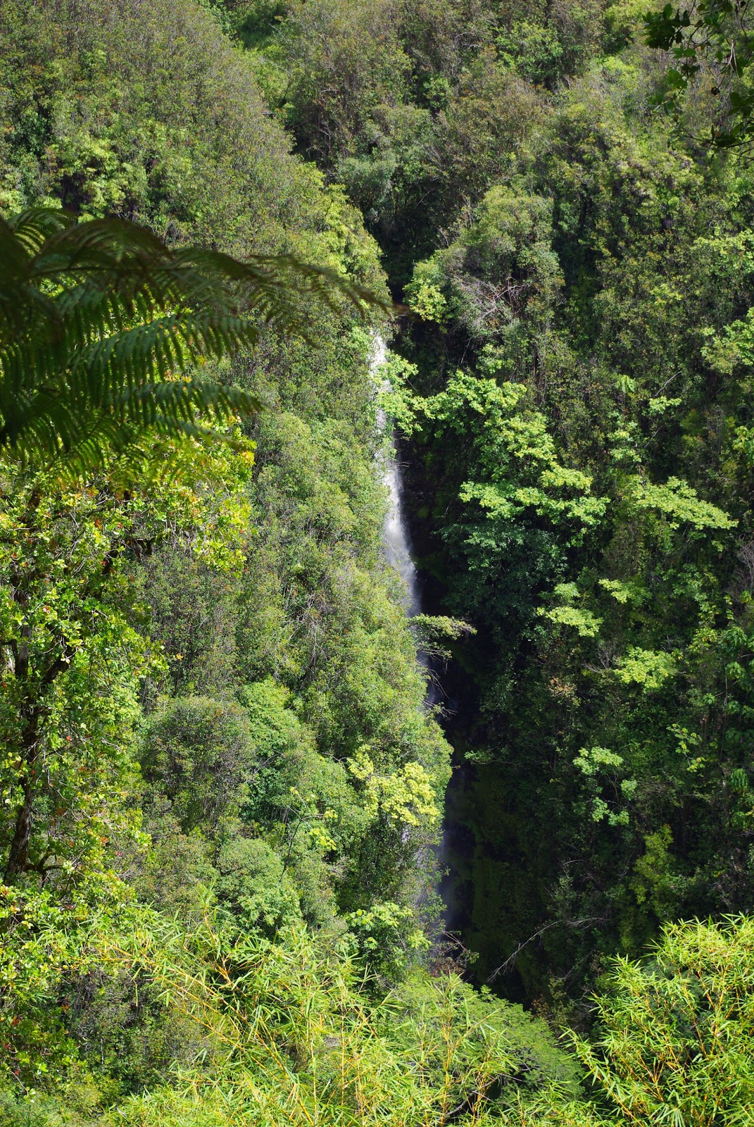
この手前に小学校と、奥に小さな集落があり、多分その関係者しか知られていない滝。この写真は河にかかる橋から撮ったもの。
There is a elementary school before this river and very small village ahead. I guess this fall is known only these people. I took this photos from the bridge of this river.


橋の先にトレッキングコースの入り口があります。手前の木はアフリカンチューリップ。真っ赤な花がいろいろなところで風景にいろどりを添えています。

自分の庭に植えていると、見ている分には素敵ですが、大形の花がしょっちゅう散って、べったり張り付き掃除が大変です。私のコンドーの駐車場の脇にこの木があって日陰と景観を与えてくれていましたが、朝起きると花がたくさんボディにしみを作っていました。(もっともレンタカーですが) 近くにあった消火栓を壊すというので、伐られてしまいましたが、ほっとしたような、がっかりしたような!!
There is a entrance of trekking course just ahead of the bridge. The big tree with red flowers in front of the fall is African-Tulip, this flowers add some beauty to Hawaiian land scape.
If you have this tree in your garden, it is wonderful for you and your neighbors to see it, but big red flowers always fall down and stick everywhere tightly, so they give you very hard work to remove them.
Near my parking place of my apartment, there was a big one, it gave me good shadow and wonderful sight, but every morning many petals make stains on my car's(rent-a-car)body. It was cut down because it would break the fire hydrant equipment near of it. Relieved and Desappointed!

2010年6月20日日曜日

ワイルク川ボイリングポッド Boiling Pod at Wailuku R.

レインボーフォールから2Km上流に、急流が煮え立つ鍋のように見えるということから、「ボイリング・ポッド」と名づけられたところがあります。レインボーフォールとは比較にならないほど美しい場所ですが、観光バスは見たことがありません。この写真は展望台から見た「ペーペー・フォール」です。
There is the "Boiling Pod" going up 2Km from the Rainbow fall. It's name comes from that rushing stream makes foam as if water boiling in the pod.

I think it is far more charming than the Rainbow Fall, but I have never seen sightseeing bus here.
It is the Pee-Pee fall( not pronounce pie but pehe) seeing from the lookout point.


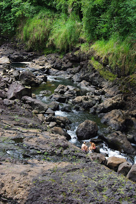
こんな急流で女の子たちが水遊びをしていました。あとは誰もいません。絶好の弁当スポットです。Girls were bathing in such rapid stream. There was no one around except them. It is the finest spot to take Obento(lunch).


写真を撮っていいかと叫んだら、彼女たちもハンサムな男性が好きと見えて、ポーズを取ってくれました。自分でも惚れ惚れするほどいい写真です。誰か彼女たちを知っていたら、連絡先をコメントに入れてください。紙焼きを送ります。
I shouted to them "May I take your Photos?" They also loved handsome man, so made a pose like this. I, myself, am fascinated this picture very much. Some one knows them please note their address or something in Comment Column of this blog, I'll send them Print.

駐車場にあったパパイアの木。最も黄色い実は手の届くところにあったので・・・おいしかった!
The papaya tree at the parking place. The most yellow one was within my reach. So...! Delicious!

2010年6月19日土曜日

ワイルク川レインボーフォール Rainbow fall at Wailuku R.


ワイルク川を2Kほど上がったところにあるレインボーフォールです。前の地図を大きくしてすこし西にずらすと出てくると思います。前に載せたアカカ・フォールの小規模版です。何回行っても虹を見たことはありません。観光バスはしょっちゅうですが。
Rainbow fall, 2Km upper way of Wailuku River. You can find it in the map making bigger and moving it to west.
It is smaller version of The Akaka falls that I posted it before. I have been there so many times but I have never seen the Rainbow, but sightseeing buses.

ワイルク川河口 The mouth of Wailuku River


ヒロのダウンタウンのすぐ北側を流れているのがワイルク川です。緑の矢印がファーマーズマーケット、その一体がダウンタウンで、町の中心部ともいえる場所です。ワイアヌエヌエ通りはそのメインストリートです。古い橋(1938年の年号があります)の、向こう側がヒロ湾で、北に向かうハイウェイが走っています。立体交差ばかりでなく、時々信号もありますが、最高速度55マイル(88k)と高速道路並です。


The Wailuku River flows just over the north side of Hilo down town. Green allow indicate the place of Farmers Market, center of the town. Waianuenue St. in the main street of it. Over the old bridge( Panel indicates 1938) is Hilo Bay and highway to the north. Hawaiian High ways have many grade crossings, not only multilevel crossing, and go-stop signals, but maximum speed limit is 55mils, just like Japanese High Ways.


ケアウェ・ワイルク橋の次の橋から撮った写真で、まるで深山幽谷の渓谷美です。水もきれいで子供たちが浮き輪で遊んでいます。町の真ん中にこんな風景があるところがヒロの魅力です。

This was took from the next upper bridge of Keawe-Wailuku Bridge. As if this deep valley is in the deep mountains. Clear and rich water, children always play in this with float. It is one of the Hilo's charm-point to have such beautiful sight in the center of the town.


2010年4月29日木曜日

ウマウマ滝 UmaUma falls

19号線を北に上がって16マイルマーカー付近を左折すると、建設中だが観覧可能($8)の「ワールド・植物園」があり、そこを左に行くとこんな素敵な滝に行き着く。(ゲートによると入園料を取られる)
原生の熱帯雨林の中に「ウマウマ滝」と呼ばれる三段の滝が見れる。
Turn to the left after 16 mile maker of the Route 19 to north, you can see the gate of the "World Botanical Garden" and turn to the left here, you'll go to the Falls of three steps in the virgin tropical rain forest, named "UmaUma Falls". World Botanical Garden is on the way of constructing, but you can see them paying $8. Also you have to pay entrance fee if you visit gate and get map, even just want to see the falls only.


地元でもあまり有名ではないが、こんな瀟洒な美しい滝は見たこともないほどで、ぜひコーヒーでも持参して雰囲気に浸るといいと思います。ここで人に会ったことはありません。
Although it is not famous but I have never seen such elegant falls. It is better to bring coffee or something to wallow in this quiet and peaceful atomosphere.


2010年3月25日木曜日

アカカの滝 Akaka fall


ヒロから20kmほど北に行ったとことに、アカカ・フォールという大きな滝があります。華厳の滝に似た正統派?の滝で、落差は128mですから、97mの華厳の滝よりはかなり高いものです。水量は華厳の滝ほどではありませんが、雨の日に行った時はその迫力に驚かされました。

滝の入り口にホノムというふるい小さな集落があります。ちょっとシャレた小物店とかピッツァの店があって、寄ってみる価値は十分あります。ピッツァはおいしかった。

About 20km north from Hilo, there is a big waterfall named Akaka falls. It is very orthodox type? of waterfall, just like Kegon fall in Nikko, Japan. It is 128m high, so a little bit toller than Kegon, 97m, about the volume of water Kegon is much more superior. But I visited there in rainy day, I was overwhelmed by its dynamism.

There is a small village at the entrance of the falls, Homomu. It has a little nice accessory shop and Pizza house, is worth to visit. Pizza was delicious and big enough.

2010年3月19日金曜日

ポロル渓谷 Pololu Valley

まづ、コハラの地図で地形をクリックし、一番北にある谷が、このポロル渓谷です。山脈で雨をすべて降らせて、川が無数にあるのが分かると思います。航空写真に変えて見るとまさにフェーン現象を起こして、西側には雲ひとつありません。
展望台から沢山の切り立ったがけが見えるでしょう。雨と波に100万年近く浸食された結果です。遠方になだらかな稜線が見えると思いますが、マウナ・ロアの稜線で、雨に削られてはいますが、まだその先端部分を波に崩されてはいません。ハワイ島は若い島ですが、それでもこのぐらいの変化があります。カウアイ島は500から700万年ですので、この変化がもっと進んでいます。いつかご紹介できると思います。
At first you see the map of Kohala, and click the rightmost box of the map so topography map opens. The Northernmost Valley is Pololu Valley. East part of the Kohala mountains, rain made so many rivers. When you click next box, the aerial photo map, you can see typical foehn phenomenon, all clouds stopped by the mountain so there is no clouds in west side of the mountains.
From the look-out so many steep cliffs are seen they were made by rains and big waves for almost 1 million years. Gentle slop is seen in the background, it is Mauna Kea's skyline. They were eroded by rain so many rivers and waterfalls are there on the slope, but waves were not collapsed so severe yet, the height of sea shore cliffs 10~20m. Hawaii island is very young one, but 1 million years made many different type of landscapes.


展望台から120mぐらい降りた海岸です。奥からの川が砂の下を流れる、いわゆる水無し川になっています。静かな所で、この日は人っ子一人いませんでした。車は入れません。

Beach is down 120m from the Look-out. The river from the deep part of the valley go under the sand at sea shore so you can easily walk across it. Very quiet place there were no man at that day. Car cannot drive in even the 4WD.


海岸から北を見ています。遠浅な感じで海水浴にはぴったりのようですが、Rip Current と呼ばれる激流が起こり沖に流される危険があるとのこと。ここで食べたサンドイッチとコーヒーのおいしかったこと。

Looking at north. The sea looks very shallow and good at swimming but there are strong Rip Current it carries you to the off shore. But the lunch we took there so delicious, sandwich and coffee, we bought them at super-market of Waimea town.