ページ

2010年2月25日木曜日

ヒロの街 1 Town of Hilo

上空より見たヒロの街。人口4万人だが、ハワイ州第二の都市(一番はホノルルで人口87万人)。東京人の私から見ると、もったいないほど空間と緑と水の多い、町全体が公園のような町。しかし、近年2度(1946年,1960年) 津波に襲われている。(津波という日本語は、英語になっている。) そこで、最近の建物は1階部分は住居がなく、波が通り抜ける設計になっているものが多い。


Hilo town from the air. The second largest town in the state of Hawaii,population is 40,000. (largest is Honolulu, population is 870,000.) There are so much space, green and water as I, Tokyo resident, feel wasteful (mottainai). It looks whole town is a park. They were attacked twice by Tsunami, 1946 and 1960. (Japnese word Tsunami becomes English. It was called tidal wave before, but it has no relationship to tide.) For wave passing through the building, the first floor of recent building has open space.


町の真ん中にあるワイロア州立公園。

Wailoa State Park, there is in the center of the town.


2010年2月18日木曜日

ヌーディスト・ビーチ  Beach used by nudists

道に車が何台も駐車しているので、かなり高い崖を降りてみると、底には小さな砂浜があって、海水浴をしていた。よく見ると(画面をクリック)何人かは水着をつけていない全裸なのです。
Many cars were parking beside the road, so I thought there were something fun at the beach. Down the high cliff I reach little black sand beach, many people enjoyed swimming there.
To my surprise, some of them wore nothing, all naked. (click photo)


エデンでりんごを食べる前と同じで、裸でいることを別に恥ずかしいと思ってもいない様子です。
私は、一眼レフのカメラを持って入ったのですが、誰もなんとも言いませんでした。もちろん裸の人にレンズを向けて「ハイ!チーズ」などとはやりませんでしたが。
As if before we made original sin, nobody thought it is shy to be naked or to see naked ones.
I brought a big camera into a beach but no one complained about it.
Of course I neither focus to them nor said "Hey! you! Say cheese"

楽器に合わせて唄ったり踊ったり、日光浴を楽しむ人もいれば、荒波にもかかわらず泳いだり、それぞれが自分なりの楽しみ方をしていた。ここはエデンの園、まだへびはいない。
Some one dancing and singing with old Hawaiian instruments, some one sunbathing or swimming in rough sea. Everybody enjoyed own way.
It is the Garden of Eden but snake dose not come yet.

2010年2月16日火曜日

生活 1 living

ハワイ島では当然ながらトロピカルフルーツがおいしくて安い。この写真にある果物全部で$3ぐらいといったら驚くでしょう。大量の青いバナナとアボカドはコンドーの庭で取ったからタダ。


Tropical fruits are very delicious and cheap in Hawaii, of course. Don't you feel surprise All fruits in this photo are only $3. There is trick, green bananas and avocado were free because I picked them up in the garden of my apartment.


パイナップルは$2、黄色のバナナは一房10本で$1、問題はパパイヤ、スーパーの石井で1っこ1290円だったものが、7個で$1。一番手前の果物は名前を忘れましたが$1でした。(いずれもヒロのファーマーズマーケットで)


Pineapple was $2, yellow bananas of ten pieces were $1,Papayas were $1 for 7.(It was ¥1290 for one at Supermarket Ishii in Japan) at farmer's market in Hilo.


白い蘭が挿してある花瓶に注目。拾った椰子の実の中央部を半分に割って作ったもの。蘭によく合うと自慢のものです。


Please look the vase of white orchid carefully. I made it with coconut. I am proud it looks very good for orchids


バナナを収穫したバナナの木。房を切った瞬間、樹液が飛び出しズボンとシャツに濃い茶色のしみをつけた。何度洗っても取れないので、考えようにやっては高いバナナであった。

These were Banana trees that I got them. When I cut the bunch of bananas, sap gushed out from cut end and pour on me and made dark brown stains on my pants and shirt. I could not remove them either washing or using stain remover.

So those bananas were very expensive ones. 

この右側にアボカド(アボガドと発音したらどうしても通じない。アボケ-ド Avocadoだとおしえられた)の大木があり、実が落ちてくる。サラダに入れると本当においしい。

There is a big avocado tree on the right side of banana. Some times the ripe avocado fall down. Add salad it is very tasty. (So many Japanese think it is avoGAdo. It is wrong.)

2010年2月15日月曜日

マウナ・ケア山頂 Summit

マウナ・ケアへはヒロとコナ方面を結ぶ200号線をヒロから行くと右折する。この道はケアへの登山道。この辺で標高2000m。ヒロが雨でもここまで来るとこの通り。でもこんな道が頂上までと思うと大間違い。最後は4WDでないとという感じ。

Access road to Muna Kea sumitt. Coming from Hilo you will find this road on your right at almost middle point of Rout 200 that connect Hilo to Kona. Its elevation is 2000m, so if you start Hilo in rain, it will be clear up like this photo. It is big mistake if you think this fine road brings you to the summit. Near the top it will be unpaved road and no guard rail. It is better to go there by 4WD.


マウナ・ケアの本当の頂上。天文台のある台地から少し下がってスコリア丘を登る。近いようだが、空気が薄いのでこれが大変。ネイティヴ(原住民)の祭壇があり捧げ物(offering)がある。
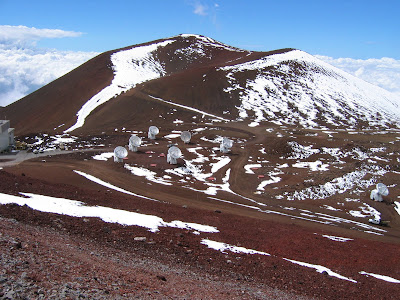
Mauna Kea’s true summit. Little down the plateau of observatories, and climb scoria hill. It looks so close but it is hard work to go there because of thin air. There is an alter and always some offerings by native Hawaiians.

雪が残るスコリア丘のそばには、電波望遠鏡が。ここでスキーをする人もいる。

There are many radio telescopes at the foot of big scoria cone with snow. Some people enjoy ski here.

日没直前の頂上。遠方の山はマウイ島のハレアカラ国立公園。

Just before sunset. The distant mountain is HaleaKala National Park in Maui Island.

スバル望遠鏡の主鏡。直径8m。建設当時世界一の一枚鏡(関東平野の大きさにしてもで1mmしかでこぼこがない)の望遠鏡。中は寒いし、酸欠で動き回るのが一仕事。週3日、8人づつ1日3回公開。もちろん昼間だから望遠鏡はのぞけない。

Giant mirror of Subaru telescope. Diameter of this is 8m. It was the biggest single mirror in the world when it constructed. Though this mirror expands Kanto plains wide, there is less than 1mm unevenness. In the observatory it is very cold and very hard to move by oxygen shortage. It published three days a week, three times a day for 8 persons. You cannot see the stars through telescope, because it opens at daytime.

2010年2月14日日曜日

地図 1 南東部


大きな地図で見る

大きな地図を見るにして、航空写真にすると周りの状況がよく分かります。特にマウナ・ロアやキラウエア上空をクローズ・アップして(+)見てください。

キラウエア火山 1 Kilauea


キラウエアは巨大なマウナ・ロアの中腹にあり、単独の山の形をしていないため、ロアの寄生火山と見られやすいが、完全に独立した火山であるそうな。有名なカルデラの高度が1200mで、サミットはその近くにあるはずだがよく分からない。1248m カルデラは周囲12k、長さ4k、巾3.2kという巨大なもので、その中に直径1kノハレマウマウクレーターがある。(直径2k以上をカルデラと呼ぶ)
Kilauea exists just halfway of huge Mauna Loa and its shape is not like a single mountain, sometimes we misunderstand it is a parasite volcano. But it is said perfect independent volcano. Elevation of famous Caldera is 1200m and summit (1248m) should be close but we cannot recognize it. Kilauea Caldera is such huge one, 12km in circumference, major axis 4km and minor 3.2km. In Caldera there is a big crater named Halemaumau, diameter 1km, 400m depth from the caldera floor. (We call Crater, not caldera, it has a diameter of less than 2km)
写真はヴォルケーノハウスというホテルから、ハレマウマウを遠望したのも。それが突然
Grand view of Kilauea and Halemaumau from the restaurant of Volcano House. Suddenly!!!

25年ぶり2008年3月19日にこのような頂上噴火。(この写真は3月26日)

For the first time in 25 years, summit caldera eruption begun at Mar. 19. 2008. (I took this picture at Mar. 26)


イキクレーターからの遠望も(背景の丘はマウナ・ロア)

The vista from Iki Crater before eruption.(Hill like mountain of background is Mauna Loa)


というようになった。迫力には富んだが、カルデラ一周の道路は今も閉鎖中。
Now it becomes very dynamic view. But road around the caldera is still closed. We can drive only 1/3 of round rout.

2010年2月13日土曜日

マウナ・ロア 1  Mauna Loa


長い山を意味するマウナ・ロア。私の一番好きな山ですが、どう写真を撮っても丘にしか見えず、とても4169mを表現きません。それだけにこの山、世界で一番ヴォリームのある山で、富士山(これも大きな山ですが)100個分に相当するそうです。また、海底からまともに吹き上がっているため山本体の高さは9600m以上で、マウナ・ケアより高いという説があり、(山の重量で海底がへこんでいる分だけ)そうだとすると世界一の高さの山。
もちろん活火山で、一番最近は1984年で溶岩流は一番近い家まですうマイルとヒロに迫ったことがあります。この写真は南斜面で、海岸から数キロのところから取っています。手前は島を一周する国道が走っています。

Mauna Loa means Long Mountain. It is my favorite one but I cannot express its height, 4169m, when I take photos, just take big hill. It is the most massive mountain in the world. It is equivalent of 100 Mt.Fuji (although it is a very big mountain)
This blows up from the ocean floor, its depth more than 5000m, so Mauna Loa has about 9600m elevation, it is the highest mountain in the world. (Usually said Mauna Kea is highest in the world from the sea-bed, but some one says sea-bed at Mauna Loa is deeper because its weight push down it below. Ha!ha!ha..)
The active volcano, of course, the most recent lava flows in the year 1984 got closer in a few miles to the houses of Hilo. This photo is the southern slope of it, taken from a 2~3km from coast line, at the side of main road runs around the island.
マウナ・ロアの頂上カルデラ(モク・アウェオウェオ)。大きな山なので馬鹿でかいカルデラとクレーターが4っほど並んでいる。ここまで溶岩台地を空気が薄いのでぜいぜいとただひたすら登る。草木一本ない。人ともほとんど合わない。(2パーティに会っただけ)
Mauna Loa’s summit caldera (Moku Aueoueo). Very big mountain so it has 4big crater and caldera. We just walked with gasp on the Lava plateau, with neither tree nor glass, we also did not see people as far as could see. (only two parties met)
北斜面の標高3000mに気象観測所がありそこまでは車がかろうじて登るので、平らな丘を1000m登るだけと軽く考えたら、ひどい目にあって1回目は断念。
There is weather observatory at 3000m elevation. A car barely can climb to that point. So I thought it was not so difficult to climb only 1000m such a gentle slope. That was a stupid notion, thin air gave me terrible suffering so gave up going a top at first trial.
上の写真の南斜面から登ると、3日間かかる。 (途中と頂上にキャビンがある)
If we climb from southern slope, above photo, need three days trip. There are two cabins on the way and top.


マウナ・ケアとロアのせめぎあいの部分。後方がケア。スコリア丘(チンダーコーン)を作るケアとロアのっぺりした溶岩(パホエホエ溶岩ーハワイ語だが火山学の専門用語)の対比が面白い。

The front line of Mauna Loa and Kea battle. The rear is Kea. Kea makes many scoria corns and Loa flows smoothie Lava (pahoehoe lava, it is Hawaiian word but it is technical term of geology). They make interesting contrast.

2010年2月12日金曜日

マウナ・ケア 1 Mauna Kea


マウナ・ケア(冬には雪が積もり白くなるのでケア・白い山と呼ばれている)は標高4205m(富士山より450mも高い)、ハワイ州で一番高い山。日本のスバルを含め天文台が数多くあるので有名。
Mauna Kea is the highest mountain in the State of Hawaii, 4205m above sea level, 450m higher than Mt.Fuji. It is called White(Kea) mountain because its top becomes white with snow when winter.
It is very famous, as there are many astronomical observatories on the summit.


この写真はヒロの海岸からまともに4200m見上げたところで天文台が白くみえる。この海岸は美しい湾で、砂地も少しある。亀も泳いでいる。
This photo was taken from the coast of Hilo. You look up 4200m so you see the Observatories just white spots.
It is a beautiful gulf beach with sand little bit. Sometime Turtles swim with us.
マウナ・ロアの頂上は天文台が林立している。一番左側の特殊な形をしたのがスバル
Many Observatories are there on top of it. Subaru has deferent form from others, leftmost, and Keck Ⅰ,Ⅱ, right side, are typical type.

ケアの頂上に点在するスコリア丘。溶岩を小石状に噴き出して、阿蘇山の米塚や伊豆の大室山のような丘を作っている。
Many Scoria hills (cinder cone) are there in the Mauna Kea. Crater ejected so many lave balls and they were piled around there and made hill just like YONEDUKA in Aso Mt. and OOMUROYAMA in Izu peninsula.
飛行機からの遠望。右はマウナ・ロア、丘のように見えるが4163mもある。
Distant view from the airplane. Mauna Loa is right of Kea, though it is 4165m high it looks like just a hill .

2010年2月8日月曜日

ハワイ島の概要 1 The outline of Hawaii Island

1.ハワイ島はハワイ諸島の最南端にあり、オアフやマウイなど主要7島を全部あわせたより大きい島
1. Island of Hawaii is located in the southernmost of the Hawaiian Islands, and larger than another seven major islands, Oahu, Maui etc., of Hawaii archipelago.

2.ハワイ諸島は太平洋プレートのホットスポットでの火山でできていて、プレートが北に毎年10cm移動しているため、北から古い島(カウアイ島)で、ホットスポットが移動するとそこで成長が止まります。ハワイ島は、現在も噴火、南東部分では今でも新しい陸地ができて成長している島です。
2. Hawaiian Islands were made of Lava from hot spot of Pacific plate. And plate is moving to north 4 inches every year with the islands on it. Hot spot is stable. When the islands move from the spot, the growth of island was stopped. Northern Island of Hawaiian chain, Kauai, is oldest and Hawaii Island (Big-Island) is youngest. Especially south-east part of the island is growing now (making new land now)