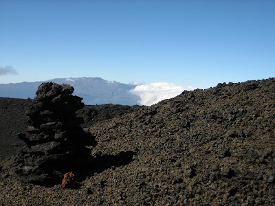
マウナ・ロアに登るために、高度3300mの気象台までは、かろうじて車でいけます。この気象台は主として温暖化ガスを測っています。そこで一時間ほど高度順化のため休憩を取ってから、この写真のような台地をただただ登っていくだけです。
I could go to the weather observatory(it mainly used to measure Green House Gases) by usual car, its altitude of 3300m. then I rest about an hour to acclimate to height. And just go up the slope like this rough field.
 背景の山はマウナ・ケア。雄大な景色です。荒い溶岩はアア溶岩。(ハワイ語が火山の専門用語になった) これが難物。ケルンに導かれて頂上に行くが、いつも霧が出たらどうしようと不安になります。
Distant view is Mauna・Kea. The rough lava is named AA(It is volcanic technical term from Hawaiian word) This is son of a bitch for walking. We guided by the cairn (guide corn) I am always scared if fog comes, it is very hard to fined them.

細かく吹き上げられた溶岩が、地上につく前に固まったシンダーの上は歩きやすい。左側の黒い溶岩はパホエホエ溶岩(同じくハワイ語が専門用語になったもの)
This is so easy to walk on the Chinder field, Lava poured like spray and become solid until it falling to the ground. The left side black lave is Pahoehoe.(also terminology from Hawaiian language)
This is so easy to walk on the Chinder field, Lava poured like spray and become solid until it falling to the ground. The left side black lave is Pahoehoe.(also terminology from Hawaiian language)

頂上カルデラの外壁。おどろおどろしい光景がまるで地獄にいるように思えます。
Outer wall of the summit caldera. Eerie scene reminiscent as if I'm coming to the gate of hell.


この写真は私の撮った物ではありません。(一目瞭然か?) モク アウェオウェオ カルデラを南側から撮った航空写真です。ピット・クレターが3っも写っている雪景色の珍しいものです。前のブログの写真と次の写真は北側から撮ったものです。次の写真に写っているケルンは、頂上ではなく山小屋に案内するものです。
This photo is not taken by me, of course. It is the summit caldera, Moku Aweoweo, taken from the south, former and next pictures are taken from north, you can see the three or more Pit Craters, it is very rare photo. The cairn signs of next photo guide to the cabin, not summit.

TJさんえ。残念ながら送られていません・コメントをクリック、コメントの記入者のプルタブを押して、下から二番目の名前を選び、ニックネームを入れてください。本文を入れた後でコメントを投稿を押してください。入り次第メールで連絡します。
返信削除