ページ

ラベル マウナ・ロア Mauna・Loa の投稿を表示しています。 すべての投稿を表示

2010年4月5日月曜日

マウナ・ロア登山 Climbing Mauna Loa


マウナ・ロアに登るために、高度3300mの気象台までは、かろうじて車でいけます。この気象台は主として温暖化ガスを測っています。そこで一時間ほど高度順化のため休憩を取ってから、この写真のような台地をただただ登っていくだけです。
I could go to the weather observatory(it mainly used to measure Green House Gases) by usual car, its altitude of 3300m. then I rest about an hour to acclimate to height. And just go up the slope like this rough field.

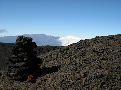
背景の山はマウナ・ケア。雄大な景色です。荒い溶岩はアア溶岩。(ハワイ語が火山の専門用語になった) これが難物。ケルンに導かれて頂上に行くが、いつも霧が出たらどうしようと不安になります。

Distant view is Mauna・Kea. The rough lava is named AA(It is volcanic technical term from Hawaiian word) This is son of a bitch for walking. We guided by the cairn (guide corn) I am always scared if fog comes, it is very hard to fined them.


細かく吹き上げられた溶岩が、地上につく前に固まったシンダーの上は歩きやすい。左側の黒い溶岩はパホエホエ溶岩(同じくハワイ語が専門用語になったもの)
This is so easy to walk on the Chinder field, Lava poured like spray and become solid until it falling to the ground. The left side black lave is Pahoehoe.(also terminology from Hawaiian language)


頂上カルデラの外壁。おどろおどろしい光景がまるで地獄にいるように思えます。
Outer wall of the summit caldera. Eerie scene reminiscent as if I'm coming to the gate of hell.


この写真は私の撮った物ではありません。(一目瞭然か?) モク アウェオウェオ カルデラを南側から撮った航空写真です。ピット・クレターが3っも写っている雪景色の珍しいものです。前のブログの写真と次の写真は北側から撮ったものです。次の写真に写っているケルンは、頂上ではなく山小屋に案内するものです。

This photo is not taken by me, of course. It is the summit caldera, Moku Aweoweo, taken from the south, former and next pictures are taken from north, you can see the three or more Pit Craters, it is very rare photo. The cairn signs of next photo guide to the cabin, not summit.


2010年2月13日土曜日

マウナ・ロア 1  Mauna Loa


長い山を意味するマウナ・ロア。私の一番好きな山ですが、どう写真を撮っても丘にしか見えず、とても4169mを表現きません。それだけにこの山、世界で一番ヴォリームのある山で、富士山(これも大きな山ですが)100個分に相当するそうです。また、海底からまともに吹き上がっているため山本体の高さは9600m以上で、マウナ・ケアより高いという説があり、(山の重量で海底がへこんでいる分だけ)そうだとすると世界一の高さの山。
もちろん活火山で、一番最近は1984年で溶岩流は一番近い家まですうマイルとヒロに迫ったことがあります。この写真は南斜面で、海岸から数キロのところから取っています。手前は島を一周する国道が走っています。

Mauna Loa means Long Mountain. It is my favorite one but I cannot express its height, 4169m, when I take photos, just take big hill. It is the most massive mountain in the world. It is equivalent of 100 Mt.Fuji (although it is a very big mountain)
This blows up from the ocean floor, its depth more than 5000m, so Mauna Loa has about 9600m elevation, it is the highest mountain in the world. (Usually said Mauna Kea is highest in the world from the sea-bed, but some one says sea-bed at Mauna Loa is deeper because its weight push down it below. Ha!ha!ha..)
The active volcano, of course, the most recent lava flows in the year 1984 got closer in a few miles to the houses of Hilo. This photo is the southern slope of it, taken from a 2~3km from coast line, at the side of main road runs around the island.
マウナ・ロアの頂上カルデラ(モク・アウェオウェオ)。大きな山なので馬鹿でかいカルデラとクレーターが4っほど並んでいる。ここまで溶岩台地を空気が薄いのでぜいぜいとただひたすら登る。草木一本ない。人ともほとんど合わない。(2パーティに会っただけ)
Mauna Loa’s summit caldera (Moku Aueoueo). Very big mountain so it has 4big crater and caldera. We just walked with gasp on the Lava plateau, with neither tree nor glass, we also did not see people as far as could see. (only two parties met)
北斜面の標高3000mに気象観測所がありそこまでは車がかろうじて登るので、平らな丘を1000m登るだけと軽く考えたら、ひどい目にあって1回目は断念。
There is weather observatory at 3000m elevation. A car barely can climb to that point. So I thought it was not so difficult to climb only 1000m such a gentle slope. That was a stupid notion, thin air gave me terrible suffering so gave up going a top at first trial.
上の写真の南斜面から登ると、3日間かかる。 (途中と頂上にキャビンがある)
If we climb from southern slope, above photo, need three days trip. There are two cabins on the way and top.


マウナ・ケアとロアのせめぎあいの部分。後方がケア。スコリア丘(チンダーコーン)を作るケアとロアのっぺりした溶岩(パホエホエ溶岩ーハワイ語だが火山学の専門用語)の対比が面白い。

The front line of Mauna Loa and Kea battle. The rear is Kea. Kea makes many scoria corns and Loa flows smoothie Lava (pahoehoe lava, it is Hawaiian word but it is technical term of geology). They make interesting contrast.