 まづ、コハラの地図で地形をクリックし、一番北にある谷が、このポロル渓谷です。山脈で雨をすべて降らせて、川が無数にあるのが分かると思います。航空写真に変えて見るとまさにフェーン現象を起こして、西側には雲ひとつありません。
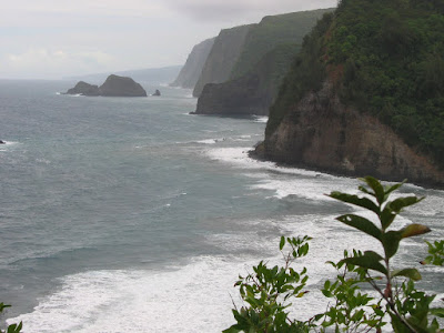
展望台から沢山の切り立ったがけが見えるでしょう。雨と波に100万年近く浸食された結果です。遠方になだらかな稜線が見えると思いますが、マウナ・ロアの稜線で、雨に削られてはいますが、まだその先端部分を波に崩されてはいません。ハワイ島は若い島ですが、それでもこのぐらいの変化があります。カウアイ島は500から700万年ですので、この変化がもっと進んでいます。いつかご紹介できると思います。
At first you see the map of Kohala, and click the rightmost box of the map so topography map opens. The Northernmost Valley is Pololu Valley. East part of the Kohala mountains, rain made so many rivers. When you click next box, the aerial photo map, you can see typical foehn phenomenon, all clouds stopped by the mountain so there is no clouds in west side of the mountains.
From the look-out so many steep cliffs are seen they were made by rains and big waves for almost 1 million years. Gentle slop is seen in the background, it is Mauna Kea's skyline. They were eroded by rain so many rivers and waterfalls are there on the slope, but waves were not collapsed so severe yet, the height of sea shore cliffs 10~20m. Hawaii island is very young one, but 1 million years made many different type of landscapes.

展望台から120mぐらい降りた海岸です。奥からの川が砂の下を流れる、いわゆる水無し川になっています。静かな所で、この日は人っ子一人いませんでした。車は入れません。
Beach is down 120m from the Look-out. The river from the deep part of the valley go under the sand at sea shore so you can easily walk across it. Very quiet place there were no man at that day. Car cannot drive in even the 4WD.
海岸から北を見ています。遠浅な感じで海水浴にはぴったりのようですが、Rip Current と呼ばれる激流が起こり沖に流される危険があるとのこと。ここで食べたサンドイッチとコーヒーのおいしかったこと。
Looking at north. The sea looks very shallow and good at swimming but there are strong Rip Current it carries you to the off shore. But the lunch we took there so delicious, sandwich and coffee, we bought them at super-market of Waimea town.

0 件のコメント:
コメントを投稿