ページ

2010年3月25日木曜日

アカカの滝 Akaka fall


ヒロから20kmほど北に行ったとことに、アカカ・フォールという大きな滝があります。華厳の滝に似た正統派?の滝で、落差は128mですから、97mの華厳の滝よりはかなり高いものです。水量は華厳の滝ほどではありませんが、雨の日に行った時はその迫力に驚かされました。

滝の入り口にホノムというふるい小さな集落があります。ちょっとシャレた小物店とかピッツァの店があって、寄ってみる価値は十分あります。ピッツァはおいしかった。

About 20km north from Hilo, there is a big waterfall named Akaka falls. It is very orthodox type? of waterfall, just like Kegon fall in Nikko, Japan. It is 128m high, so a little bit toller than Kegon, 97m, about the volume of water Kegon is much more superior. But I visited there in rainy day, I was overwhelmed by its dynamism.

There is a small village at the entrance of the falls, Homomu. It has a little nice accessory shop and Pizza house, is worth to visit. Pizza was delicious and big enough.

2010年3月20日土曜日

州鳥 ネネ NENE Goose


ハワイの州鳥であるネネは、多くの特有種がそうであるように絶滅危惧種である。
キラウエアやマウナ・ロアのふもとをドライヴしていると「ネネ横断中」の標識がしょっちゅう見られる。また「ネネに餌をやらないで」という看板は、ネネが人なつっこく、餌を見せると手から食べるので、皆ネネを見ると餌をやり、それが習い性となり道路に出てきて事故にあうのが多発したためである。
個体数は最近回復傾向にあるといわれている。一昔前はヴォルケーノ・レストランでターキーみたいに料理に付け合わされていたことがあったそうな。
As many endemic birds, Nenes are endangered species. When we drive Kilauea or foot of Mauna・Loa we see many traffic signs "Nene crossing" and " don't feed Nene!" It means.....
They are very amiable so we give some food to them, they eat it from our hand. Many people gave them food and they came out to the road for food and met traffic accident so many times.
Fortunately numbers of Nene are recovering now because of protection.
In the past the Volcano House restaurant served Nene like turkey with side dish. I don't know it was true or not.

2010年3月19日金曜日

ポロル渓谷 Pololu Valley

まづ、コハラの地図で地形をクリックし、一番北にある谷が、このポロル渓谷です。山脈で雨をすべて降らせて、川が無数にあるのが分かると思います。航空写真に変えて見るとまさにフェーン現象を起こして、西側には雲ひとつありません。
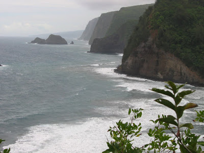
展望台から沢山の切り立ったがけが見えるでしょう。雨と波に100万年近く浸食された結果です。遠方になだらかな稜線が見えると思いますが、マウナ・ロアの稜線で、雨に削られてはいますが、まだその先端部分を波に崩されてはいません。ハワイ島は若い島ですが、それでもこのぐらいの変化があります。カウアイ島は500から700万年ですので、この変化がもっと進んでいます。いつかご紹介できると思います。
At first you see the map of Kohala, and click the rightmost box of the map so topography map opens. The Northernmost Valley is Pololu Valley. East part of the Kohala mountains, rain made so many rivers. When you click next box, the aerial photo map, you can see typical foehn phenomenon, all clouds stopped by the mountain so there is no clouds in west side of the mountains.
From the look-out so many steep cliffs are seen they were made by rains and big waves for almost 1 million years. Gentle slop is seen in the background, it is Mauna Kea's skyline. They were eroded by rain so many rivers and waterfalls are there on the slope, but waves were not collapsed so severe yet, the height of sea shore cliffs 10~20m. Hawaii island is very young one, but 1 million years made many different type of landscapes.


展望台から120mぐらい降りた海岸です。奥からの川が砂の下を流れる、いわゆる水無し川になっています。静かな所で、この日は人っ子一人いませんでした。車は入れません。

Beach is down 120m from the Look-out. The river from the deep part of the valley go under the sand at sea shore so you can easily walk across it. Very quiet place there were no man at that day. Car cannot drive in even the 4WD.


海岸から北を見ています。遠浅な感じで海水浴にはぴったりのようですが、Rip Current と呼ばれる激流が起こり沖に流される危険があるとのこと。ここで食べたサンドイッチとコーヒーのおいしかったこと。

Looking at north. The sea looks very shallow and good at swimming but there are strong Rip Current it carries you to the off shore. But the lunch we took there so delicious, sandwich and coffee, we bought them at super-market of Waimea town.

2010年3月10日水曜日

カメハメハ大王像 Statues of KAMEHAMEH the Great


コハラ・マウンテン・ロードは最北の町ハヴィに突き当たります。そこを右に折れ、ポロル渓谷に向かうとすぐのカパアウにカメハメハⅠ世像があります。実はホノルルに建てるつもりでパリから運んだものが船の沈没で海に沈んだものを、後日引き上げてここが生誕地であることから建てられた像だそうです。ホノルルの像は2作目とか。三作目は
The end of Kohala Mountain Road is Hawi, the Northernmost town in the island. Turn the right, direction of the Pololu Valley, we will see a statue of Kamehameha Ⅰ at Kapaau town that is birth place of the King. This was made at Paris to build in Honolulu, but ship sunk so second statue was made for Honolulu. Later this first one was salvaged and set up here. The third one is


ヒロのあの美しいワイロア州立公園に建てられています。一番ハンサムとか?彼の死後遺体は敵の手に渡らないように、焼かれて食人習慣のあった当時のこと、食べられてしまったようです。

It is standing at beautiful Waikoloa State Park in Hilo. They say the most handsome one is he. After his death, his body was burned and eaten to prevent to pass into enemy. At that time they have a custom of Cannibal.

(このブログの写真はクリックすると大きくなるものが何枚もあります。特に各テーマの最初の写真はそうです。画面に表示しきれないので写真の下と右横にあるスクロール・バーで動かして全体を見てください。)

( Many photos of this blog, especially the first one of every titles, become larger when click them. To see whole photo please move scroll bar of beneath and right side of it.)

2010年3月7日日曜日

地図 2 コハラ map of Kohala


大きな地図で見る
地形図を見ると、雨があるのとないのでは侵食がいかに違うか一目でわかります。写真ではコハラ山脈で雲が押さえられている様子が、一目瞭然です。クリックしながらドラッグすると地図が動きます。(-)をクリックすると地図が引かれてハワイ島全体を見ることもできます
Clik the right box at map, you can see the topographical map and see the defference of erasion between rain and dry wind. Center box indicates a photo from satellite, it shows the Kohala mountains stopping the cloud.

コハラ山脈 Kohala Mountain Road


ワイピオ渓谷で止められ、これ以上北上するにはコハラ山脈の西側を通らなければならないが、これが素晴らしい高原道路で、貿易風の風上のワイピオ渓谷側とは表情を一変させます。1500m 以上のコハラ山脈にぶつかり雨を搾り取られて乾燥した風は、西側では水の浸食ではなく、風と地すべりによるなだらかな斜面を形成します。むこう側の山は、マウナ・ロア、手前の町はワイメア、広い土地はアメリカでも有数の広さを持つパーカー牧場。

As the road of east side is stopped by Waipio Valley, We have to drive west side of the Kohala Mountains to go up north, . It is a magnificent highlands road and has quite different sight from the east side. Because it is at the leeward side of the Trade Wind so rains are squeezed by the mountains of more than 1500m high and very dry wind comes and has few rain. The land were eroded by wind and landslide, not rain and river, making gentle slope.
The mountain of back ground is Mauna・Loa, town in the foreground is Waimea and huge empty space is Parker Ranch that is one of widest ranch in USA.


サボテンがたくさん生えていて、亜熱帯雨林を形成していた東側といかに天候が違うかを示しています。 わずかな距離でこれほど植生が違うところも珍しいのではないでしょうか? ハワイらしからぬ風景です。


Many Cactus symbolizes a difference of weather from east side with tropical rain forest. It is rare places that have such difference only 10 miles away, I think.


高級ホテルで有名なワイコロア・リゾートやマウラニ・リゾートを遠望しています。雨が極端に少ないのでゴルフやスウィミングに最適。夕陽がいろどり最高のディナーを楽しめます。


It is a distant view of Waikoloa Resort, Maulani Resort and so on, they have many luxury hotels and we can enjoy fine diner at the hotel with golden sunset. West side of the island they have few rain, so it is very good for Golf and swimming.

2010年3月5日金曜日

ワイピオ渓谷 Waipio Valley

ヒロから19号線を北に上がっていくと、映画「ホノカア・ボーイ」(倍賞千恵子の独り舞台だったような気がしますが) の舞台になったホノカアから240号を経て、ワイピオ渓谷の絶壁に行く手を阻まれます。高さ約300m. ここから20kmぐらいはこれと同じような渓谷がいくつもあります。
新しい島ハワイ島では最も古いコハラ山脈 (火山だがもう活動はしていない) のふもとで、百万年近く雨の浸食を受け、キラウエアやマウナ・ロアのふもと (生まれたばかりの土地) とは全く違った景観を示しています。
なお、最北のカウアイ島などは7百万年以上経っている。
車道はあるのですが、この崖をアメ車のコンパクト・レンタカーで下りる勇気はさすがの私にもなく、ツアーに頼りました。(降りていく自信はあったのですが、問題は帰りで)

Go to north by Rout 19 and turn right to Rout 240 at Honokaa town, it was a main stage of movie"Honokaa Boy" (This movies was monopolized by the Actress Chieko Baisyou, I think), this road is blocked by high cliff, almost 300m down. It is Waipio Valley. Many same kind of deep valleys are there in next 20 miles. Here, the foot of Kohara extinct Volcanoes is oldest part of the island, near 1 million years old, and has been eroded by water and wind. They showed quite different land scape from new born land Kilauea and Mauna・Loa .
It has a way to go down the valley by car but I have no courage to go by my economy class 2WD American rentacar. Yes I could go down but how to come back. So I went there by shuttle tour.


絶壁の下は、かなり長い渓谷で奥のほうにヒイラベの滝という水量は少ないが高さ400mのハワイ州で最も高い滝があります。このようにして最北のポロル渓谷までのいくつもの渓谷ができているが、ワイピオ渓谷以外は車では入れなません。
Under the great cliff there is big and long scale of valley and Hi'ilawe falls are there deeper part of the valley. The height are almost 400m, the highest water fall in the Hawaii State. Many eroded big valleys are lying here to northernmost Pololu Valley. Another valleys cannot go in by cars.
ここには現在約50人ぐらいが住んでいて、昔からの常用食タロイモを栽培している。ヒロに大被害をもたらせた1946年の津波は高さ10mにもなったそうだが、マナという霊力のお蔭で死者は出なかったそうな。
There live about 50 peoples now and making Taro potatoes, pound into paste, they become very traditional Hawaiian foods named Poi. Please try them when you'll come to Hawaii, I ・・・never again. The big Tidal waves of 10m high that brought big disaster in Hilo came here 1946, but no one dead here by the grace of magical power of this valley, Mana!.


2010年3月1日月曜日

津波を見た Tidal Wave


前回、ヒロの街を紹介したとき津波の話に触れました。なんとその翌日M8.6のチリ地震があり、これまた偶然、九十九里の南端一宮に滞在しており、初めて津波に接することになりました。もちろん、海岸や港に出ることはできませんので、太平洋に直角に流れ込んでいる夷隅川の河口から約1kmのところで待ち構えました。とても静かな河です。(左が川下)
When I introduced Hilo town in this blog, I mentioned about Tsunami which attacked there twice. Next day we had huge earthquake at Chile, M8.6 and what an accident, I stayed Ichinomiya town at the Boso peninsula so I could watch the Tsunami for the first time in my life. Of course I could no go out to beach or haber, so I waited them at the side of Isumi River. Here is 1km up from the river mouth and it makes a right angle to Pacific Ocean. The Isumi River is very quiet and gentle one. (left of the picture is lower part of the river)


突然大量のごみが逆流してきました。かなりの早さです。後ろに写っている排水溝を見ると、かなり水位が上がっているのがわかると思います。次の写真の桟橋の角度も比較してください。
Suddenly mass of trash were flowing backwards aginst the stream very quickly.
You can easily find the level of water rises high abave, when you see the draining ditch and the angle of steps to floating pier.


手前にあった桟橋の杭を見ると、流れの方向が変わっているのと水位の変化がハッキリすると思います。この間約五分、1m近く増水しています。
Stakes of pier show the direction of flood and huge increase of water. Only in 5 minutes water increased 1m.

あと1mほど水位が上がっていたら、周りの家は床上浸水してますね。これを見て思ったこと。
If water increased 1m more all the houses around there were flooded up to the floorboard. I'm thinking now next after I saw this scien.
1. ヒロの記事で、かって英語では津波のことをタイダル・ウェーブといっていたが、タイド(潮) とは関係ないので、今では正当にもツナミと呼んでいる、と紹介したが、私が見た限りにおいては、これは、波ではなく大きな潮の流れという感じです。
I said in Hilo story, Tsunami was called "Tidal Wave" before. But there is no relation between Tide and Tsunami so word of Tsunami becomes English. It was reasonable I thought. But I saw this tsunami I'm thinking now it is not a wave but gigantic flow of Tide.
2. 波にはあれだけ大量のごみを、川の流れに逆らってすごいスピードで運んでくるパワーはないでしょう。単に上下させるだけ。引くときはあっという間に流し去って行きます。
A wave has not such power or energy to carry big mass of trash up ward of river against the flow. A wave can only move them up and down.
3. 風の力で表面だけ波立たせるのではなく、海底から水をうごかす、まさに「潮の波」でした。しかし怖いですね。音もなく寄せて音もなく去っていく。前の家などは全くこの事態に気がついていませんでした。
A wave is occured by wind mainly and happen at surface of sea. But Tsunami moves all water from bottom of the sea, we must not call them "Haber Wave-TSU-NAMI".
It is exactly "Tidal Wave" or "Tide like Wave". It is very horrible because it creeps still and goes away quiet. No one of that hause recognized this situation, of course not evacuate but might be just watching TV, it repeated so many times that it was possible one wave after another becomes bigger.
4. なお、ヒロの街は75cmぐらいのツナミで被害はなかったようです。
Hilo got no damage from tsunami of 75cm high.